Third, information and foresight.Water levels, weather patterns, cargo flows and port capacity should increasingly be treated as one interconnected data system. Strategic foresight must become part of corridor management, allowing operators and governments to anticipate disruption rather than merely respond to it.
Fourth, governance. This may be the most important dimension. Europe’s waterways cross multiple jurisdictions and policy areas—transport, environment, agriculture, energy, civil protection and regional development. Their management therefore demands institutional coordination across ministries, borders and levels of government. It also means bringing finance, insurance, logistics operators and regulators into corridor governance at the design stage, not after infrastructure is built, and treating legal certainty on liability and dispute resolution as part of what makes a waterway investment bankable.
The blue-waterway agenda should also extend beyond the traditional Rhine-Danube axis. Europe’s rivers connect its Atlantic, North Sea, Baltic, Mediterranean and Black Sea spaces: the Seine reaches the Atlantic; the Rhine, Meuse and Scheldt converge on the Rotterdam-Antwerp delta on the North Sea; the Oder and Vistula drain north towards the Baltic; the Rhône and Po serve the Mediterranean; and the Dnieper joins the Danube in opening onto the Black Sea—though the Dnieper’s own connectivity, like the Volga’s, has been disrupted by war. The Iberian Peninsula’s Douro, Tagus and Guadalquivir remain comparatively isolated from this network, a reminder that the map of physical waterways is not yet the map of a connected system (Figure 1). The opportunity is to think of these waterways as a continental blue network, linked to maritime ports and land corridors. Europe would not be alone in making this shift. From Africa’s emerging Indian Ocean, Atlantic and Trans-Saharan gateways to the Eurasian corridors linking the Middle Corridor with the International North–South Transport Corridor, the same logic is taking hold elsewhere: the strategic question is no longer which single corridor prevails, but how multiple corridors can be governed to work together as a network of networks.
Advertisement
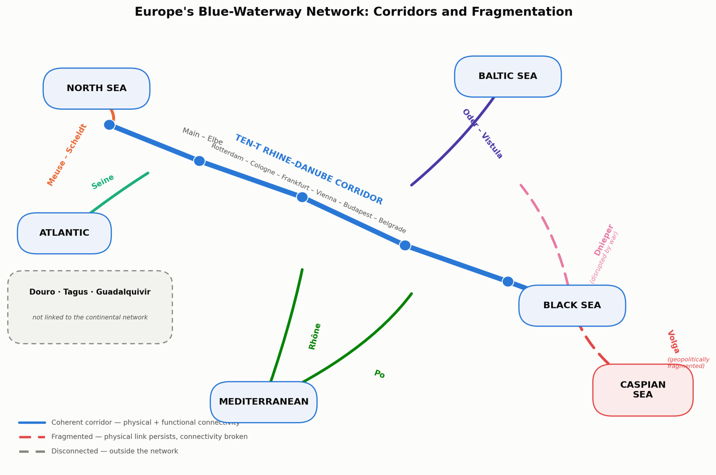
Figure 2. Europe’s principal river-canal corridors and their sea-basin connections (schematic, not to scale). Dashed lines mark corridors whose physical infrastructure persists but whose connectivity has been geopolitically fragmented.
Such an approach would complement, rather than compete with, Europe's existing TEN-T architecture. Indeed, the European Commission's current framework already recognises the importance of inland waterways and multimodal connectivity, while its 2026 Connecting Europe Facility calls explicitly support inland-waterway projects designed to make the network more sustainable, smart and resilient.
The strategic question is therefore no longer whether Europe should use its rivers more intensively. It is whether Europe is prepared to govern them as critical infrastructure. In the language now used for Europe’s maritime chokepoints, the question is whether its river gateways, like its sea straits, are ready to evolve from fixed crossing points into networked governance hubs.
The Danube's difficult summer of 2026 should be read as an early warning. A waterway cannot be resilient merely because a channel has been dredged or a port modernised. Resilience emerges from the whole corridor—from watershed to river, from port to railway, from data to decision-making, and from one national authority to the next.
Europe's future connectivity will not be exclusively green, digital or terrestrial. It will also be blue.
Advertisement
And if the Connectivity Doctrine is correct that corridors are governance ecosystems, Europe’s rivers may become one of the most compelling places to demonstrate what that doctrine means in practice: turning fragmented infrastructure into integrated systems, and turning geographical constraints into strategic connectivity. The Global Maritime Governance Forum, convened under the same doctrine around the Strait of Gibraltar, offers one working template for the standing, cross-border dialogue Europe’s rivers now need of their own.
Discuss in our Forums
See what other readers are saying about this article!
Click here to read & post comments.
1 post so far.




 reddit this
 Del.icio.us
 Seed Newsvine
 StumbleUpon